The Problem
FEMA requested a hurricane study for most of the southern shores of the Hawaiian islands – Oahu, Maui, and Molokai. The Hurricane study included identifying coastal food prone and storm surge inundation areas for the entire coastal shoreline area of Hawaii.
The Solution
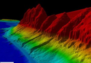
Massoud Rezakhani Consulting (MRC), LLC in partnership with RMTC/URAS Joint Venture completed the hurricane study. MRC performed field reconnaissance, LiDar data collection, quality control review, and served as the community liason and the FEMA liason in this study. The scope of work included:
- Field reconnaissance
- Collection, processing and review of LiDAR data
- Storm surge analysis
- Coastal flood hazard analysis
- Coastal flood hazard and boundary mapping
As a result of this study, the FEMA Flood Insurance Rate Maps (FIRMs) have been updated. This in turn provides accurate information to developers and residents for planning purposes and flood insurance premiums.
Project Highlights
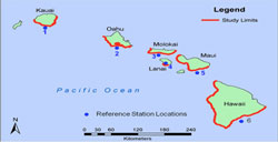
- FEMA requests a hurricane study for the southern shores of the Hawaiian islands – Oahu, Maui, and Molokai
- MRC working in partnership with RMTC/URS Joint Venture performs the hurricane study
- FEMA updates its FIRMs